
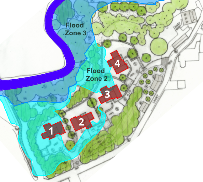
Earlier today, I wrote about proposals for four detached homes in the grounds of Linney House. The development is on the banks of the Corve. But the flood risk assessment is based on the Teme which is 600 metres (660 yards) downstream of the site and around two metres lower.
The flood risk assessment states the minimum ground level of the development will be 2.19m above modelled flood level of the Teme. That is not relevant. In October, the Corve was at a height of 3.7m. That potentially threatens one of the planned homes with flooding. A new flood risk assessment is needed based on local conditions.

The Teme is relevant to this site. If water levels in the Teme are very high, then water will back up along the Corve increasing flooding. Much like high water levels on the Corve can cause Fishmore Brook to back up, threatening some houses in Summerfields and Mayfields. But the Teme is not suitable as a reference model for understanding flooding potential at Linney House. It is a different river and too far away.
The Corve Stage Gauge is upstream from Ludlow near Elm Lodge. This logged a record level of 5.22m during the July 2007 floods. But this level of water is now highly unlikely after the rebuilding of Burway Bridge. During the last year, the gauge has registered a range of water levels between 0.86m and 3.43m according to the river levels website. I grabbed a snapshot of the Corve hitting a level of about 3.7m on 26 October.

Flood Assist Insurance confirms this, recording 3.691m.

House 1 will be 2.45m above the bank of the Corve.

If this house had been built, the risk of flooding would have been touch and go on 26 October 2019. This needs more research. Usually stage gauges are measuring height above the river bed. But I cannot determine the Ordnance Datum of the river bed at Linney House.

I am also concerned about the implications of reprofiling of the landscape for the Corve. During this winter the river has begun to shift its course and is eating into the garden of Linney House. It is possible that this is due to the river responding to the removal of most of Linney Weir by the Severn Rivers Trust. The developer says river levels have dropped following the removal of the weir. We have not seen any evidence of that over the winter.
The developer plans to raise the level of much of the land on the site classified as Flood Zone 2. This has a medium chance of flooding, between a 1 in 100 and 1 in 1,000 annual probability before allowing for climate change. Water that would have washed onto Flood Zone 2 will have to go elsewhere and the ramifications of that do not seem to have been considered. Will the river further alter its course in response? Perhaps eroding the opposite bank?
The site needs a flood risk assessment that respects its specific location. It should be based on the behaviour of the Corve and not the Teme. Although the developer is putting pressure on Shropshire Council to approve this scheme, the desk top flood risk assessment does not give me any confidence. The intensity and volume of rainfall has been increasing. It is expected that this trend will continue with global warming. We must not approve houses that have a risk of flooding.
Be blowed to those devious councillors in Shrewsbury. You do a fine job Andy for the residents of Ludlow and environs. You are the major source of information and analysis of what is going on in the town.