
The scheme for 213 homes on a wedge of greenfield land off Bromfield Road between the railway and the A49 were first proposed in 2013. They were rejected by the South Planning Committee twice but were approved by a planning inspector in 2015. A controversial footbridge linking the development with Fishmore View was removed from the scheme in 2017. That left a footbridge over the railway as the only pedestrian access to the site. Tesni, the housing developer, could not reach agreement with Network Rail on construction of footbridge.
The new proposal is to create a pedestrian and cycle path from the site that descends to the banks of the Corve, goes under the railway viaduct and through the Burway Trading Estate to Bromfield Road. This path will be raised above the current level but will still occasionally flood. Tesni’s consultants propose that a warning system is installed to indicate path closures during flood events.


This scheme was rejected twice by the South Planning Committee in 2014. But a planning inspector approved the scheme in 2015 after Shropshire Council refused to defend the committee’s decision at the appeal. But that inspector’s decision means that development on the site can no longer be opposed.
The developer, Tesni, agreed in 2017 to the removal of a controversial footbridge that would have linked the development with Fishmore View. This meant that the only pedestrian link to Ludlow would be using a footbridge over the railway to join Bromfield Road opposite the leisure centre. Network Rail, however, has refused permission for the footbridge due to “deliverability problems”.
Other options are now being sought. Shropshire Council planners have said that the former proposal for a footbridge over the railway is unsuitable anyway because it “would involve doubling back of pedestrian movements for most properties in order to access the town centre.” They are clear that they still prefer the footbridge to Fishmore View while recognising that it “attracted significant local opposition”.
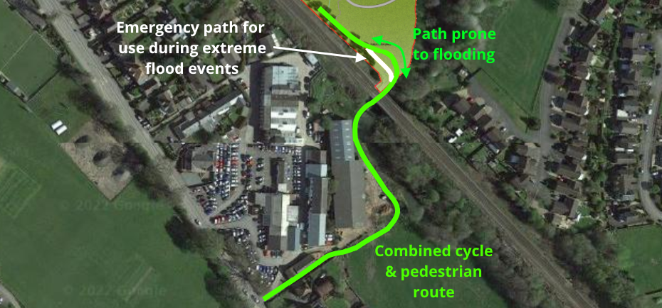
Tesni have come up with another solution (21/06007/FUL). The company is proposing a 3m wide footpath and cycleway. The footpath will be raised above existing ground levels by between 0.5m and 1.9m to ensure that it remains flood free during the most frequent flood events. When floods are higher than usual, the only access to the site will be by vehicle from a new roundabout on the A49.
It is proposed that a mix of post and rail and closeboard fencing lines the path.
The Environment Agency has said that it has no objection to the raising of levels for the footpath and cycleway by 700mm but wanted to know whether the footpath and fencing would have an impact on flooding elsewhere. The hydrological reports by Waterco there will be no impact. The Environment Agency also asks Tesni to provide net flood risk betterment by lowering a greater volume of land than that lost to accommodate the proposals. I am not sure from the plans that this recommendation has been taken up though it would not be difficult to create swales in public open space adjacent to the Corve. This would also be a good area to plant trees which would help slow the flow of the fast flowing Corve.
The proposed footpath upstream of the railway bridge is estimated to flood with depths of up to 600mm in a one in 100 year flood (allowing for climate change). There is a danger of blockages at the railway bridge and Corve Bridge during storm events, for example by trees or straw bales. A 33% blockage, for example by trees or straw bales, would increase the flooding upstream (east) of the railway bridge to 760mm.
I have difficulty with the way that flooding is talked about. It is not just that floods will be higher with climate change, they will be more frequent. This area has flooded several times in recent years so talking about one in 100 year events (more precisely a one per cent chance of flooding in any year), even one in 20 year events (five per cent risk in any year), can give the wrong impression of the risk of flooding on the site.
For clarity, none of the proposed houses are at risk of flooding, only the proposed footpath and cycleway.
Part of the footpath is at a level where it is prone to more frequent flooding. Here a steeper pedestrian path is proposed for use in extreme flood events. It worries me that anyone would be anywhere on the footpath during flood events.
Waterco advised Tesni to install an automated alert system to close the footpath when a flood warning is in place. This could include LED flood warning signs which are automatically activated when a flood warning is in place. The signs could be linked to a wireless sensor in the river which would activate the flood warning sign when a designated river level is reached. A warning could be triggered when water levels are within 300mm below the footpath level. Footpath closure could be activated when water levels are within 150mm below the footpath level.
Planning officers have said that any application should include “the mechanism for pre-empting worst case flooding events, closing the underpass and notifying residents” but details of a warning system are not included in the plans for the current application.
Officers say that if they cannot be assured of the safety of scheme, the option of providing the footbridge at Fishmore Road should be re-visited – even if this is as an emergency access which is normally closed. That would not be desirable as it would make Fishmore View a through route for pedestrian and cyclists and significantly reduce its green space, which is owned by Shropshire Council not Tesni.
Could they perhaps add a footpath up to the roundabout, over the A49 railway bridge and down towards the school? Because people are going to walk that way whether they do or not.
I really disagree with the decision not to have the footbridge over the Corve. The residents of Fishmore View might not be keen to have people walking past but pedestrian routes like this are essential to save people from driving everywhere. Particularly if the only alternative is prone to flooding. Save the pointless flood sensors (which will be entirely ignored) and stick a bridge in. The kids will get across that way when the rivers low anyway.