
This is a second of a series of articles on the Ludlow Local Cycling and Walking Infrastructure Plan (LCWIP). It looks at some of the principles on which LCWIP is based and the constraints that limit its scope.
The LCWIP describes Ludlow as being “relatively flat”. Those walking up Sheet Road or Dinham might not agree with that. Other than mentioning drop kerbs on Corve Street and the need for level access at the railway station, which it notes is in progress, LCWIP seems totally unaware of disability.
I can’t understand why a study of infrastructure options for walking does not have disability at its core. This should have been written into the objectives of the study.
LCWIP is not an integrated travel study, so it doesn’t include any consideration of buses. It lacks a comprehensive strategy for managing traffic. The Ludlow LCWIP is a starting point but a long way from the sort of study and strategy we need to get to grips with Ludlow’s travel and accessibility issues.
The LCWIP study arises from a consultancy funded by the Department for Transport to look at walking and cycling, not at any other form of transport in the town. It does not look at the town’s overall transport needs.
It does not present a comprehensive scheme for managing vehicle traffic in the town centre or across the town. Yet one of the most obvious ways to improve the cycling and walking experience, is to reduce traffic and traffic speeds. LCWIP offers piecemeal 20mph limits without adopting a blanket 20mph limit on all residential roads. This would be easier for drivers to understand and cheaper to implement.
The study’s remit does not include buses, which are a vital tool in reducing traffic. We require a more frequent bus service, especially from the park and ride. Buses will need to access the historic town centre but there is no mention of this in the proposal to close King Street and High Street, which are used by around 50 buses a day.
This is not the fault of the consultants, City Science, they had a brief and worked to it. But it means this study can only be the starting point for a sustainable travel strategy for Ludlow.
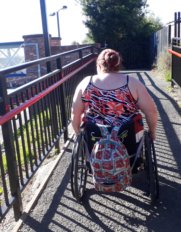
The biggest difficulty with LCWIP is that it takes no account of disability. More than one in five people in Ludlow said they had a disability that affected their lives in 2021 (22%). This is higher than Shropshire as a whole or England and Wales.
Disability is only mentioned once in the consultation, dropped kerbs on Corve Street. There is also mention of level access at the station where a lift is due to installed by the end of 2024.
Disability takes many forms. People may have obvious physical disabilities limiting the distance they can walk or their ability to go up and down steps. Some use wheelchairs or mobility scooters.
Others have visual impairments, from complete blindness to having different degrees of visual acuity. Deafness can also cause problems in getting out and about. There are also hidden disabilities. For example, autism, chronic fatigue or pain and a range of mental health conditions, including dementia.
There is there is the by no means small question of getting smooth pavements, removing trip hazards, ensuring pavements are cleared of snow, ice and leaves and obstacles are removed. However, these are not infrastructure issues.
Disability is a topic that needs its own consideration. There is no point in having an infrastructure plan for walking without a policy for those walking with a disability.
Don’t forget those who live in the Bringewood area. Steep inclines into town and appalling lighting/ pavement access particularly on the Hucklemarsh Road as it approaches Dodmore. This is a main pedestrian accceds route to town. I can no longer use this after dark. And there is no public transport access to town after the buses cease at 5.30. The recent fair passed many people by as there were no buses over the bank holiday. Many people would like to access evening and weekend events but are unable to. The taxi situation is totally inadequate.
Oh, I had to laugh at that Andy – I would think the only “relatively flat part” of Ludlow is from the Castle via the Bull Ring, Tower Street and perhaps as far as the New Street/Henley Road roundabout. For almost everyone who shops in Ludlow there are steep walks to and from all the supermarkets and the centre of town. Have these people ever even been to Ludlow?
I’m not a Ludlow resident although I enjoy visiting the town. One note of caution: if the Shresbury Big Town Plan is anything to go by, you’ll need to scrutinise any map of proposed walking/cycling routes very carefully. The plan in question appeared to have been prepared from a map without walking the ground: some decidely improbable routes had been deemed suitable for cycling.