
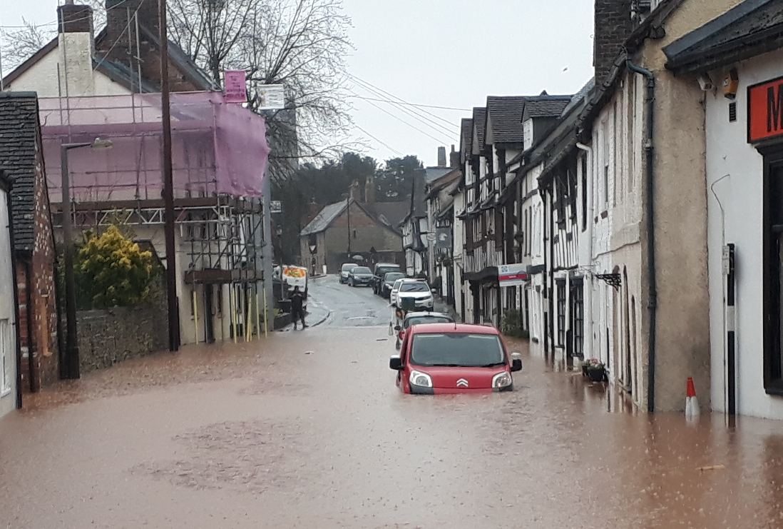
Temeside and Lower Corve Street are flooded. Other areas also. The water has rushed in through doors, flooded basements and pushed sewerage out of toilets. It is not yet known how many houses are flooded but it must be around 20. Water is lapping at the doors and back gates of many other properties.
This is almost the worst flood since July 2007. Then water reached a height of 5.22m on the Teme. Today, the river seems to have peaked at 5.20m. But no one threatened with river water pouring into their home cares about whether this is a record flood or not.

BBC Radio Shropshire has been excellent through the day. It scrapped schedules which would have taken it into regional programming this afternoon. It has put local presenters on the air to keep everyone updated and plans to do that until 10pm. (I hear Sunshine Radio has been good too but I haven’t been listening.)
There are lessons to learn from this. Shropshire Council’s emergency number was not available until 9am. Ludlow Town Council doesn’t seem to have an effective emergency plan or number in place.
Today, the problem is water. Far too much of it. Tomorrow, it could be COVID-19 or any other emergency. We need to take emergencies seriously and plan for the unknown. In meanwhile, we must help those suffering from Storm Dennis. I know that many people in Ludlow are already doing this. Thank you.


I propose a new Council Tax Band for properties – like mine in lower Corve Street – located within postcodes designated by the EA/authorities as ‘High Risk’ from river and surface water flooding.
This would reflect the significant reduction in amenity value resulting from the failure of government and local government to manage infrastructures or deal properly with the risks – until such time as those risks had been minimised or eliminated.
Instead, politicians rely on insurers to bail out flood victims. And flood victims find themselves totally at the mercy of the loss adjusters.
Cutting CT to owners of affected properties would help to focus minds of the authorities on the need to stop building on flood plains, to dredge rivers, keep drains unblocked, fit flood defences and have a coordinated national flood plan so that the authorities don’t pass their flood problem on to downstream communities.
I am sure that your sources of river levels must be sound, Andy, but they do not tie in with my measurements.
I have been weirs manager for 20 years on the Teme here and I made a water depth gauge at the Casemill – next to Teme vets.
In July 2007 the level there was 14 feet of total water depth. Today, at around 14:30 the river peaked at 15 ft. It was considerably higher than in 2007 and I photographed the full course of both floods. There was far more destruction around the vets’ property and the water levels on the whole Temeside road were mostly well over full wader depth. This was not the case in 2007 when I attended that flood throughout the night.
So I am not quite sure how to reconcile your figures, but I can assure you that this was by far the highest flood in most living memory.
Perhaps that of 1947/48 may have been higher, but the topography has altered a lot since then.
The data is from the Environment Agency guage on Temeside.
https://flood-warning-information.service.gov.uk/station/2086
Thanks Andy
I’m afraid that confirms and compounds my (lack of) faith in the EA’s contact with conditions ‘on the ground’.
I have the photos to prove my claim.