
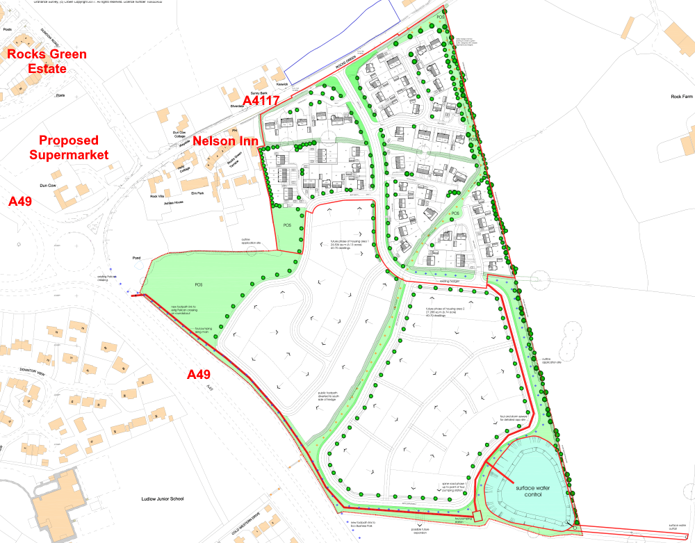
Pickstock Homes has submitted a planning application for 200 homes behind the Nelson Inn. The application is a so-called hybrid application. It is in outline for the full site and a full planning application for 68 of the homes. The site is allocated for housing in the local plan, SAMDev. The scheme is essentially the same as that presented to the town council and Ludford parish council last summer. It is expected to take six years to build.
 The overall scheme will deliver 15% affordable housing, 30 homes, but the first phase will deliver only eight affordable homes (12%).[1]
This development is in our local plan and I am sure it will go ahead. I think its sustainability could be improved and I would ideally like to see a masterplan for the whole area from Rocks Green to south of Sheet Road before any more development is approved east of the bypass.
The site has a lot of constraints and these have shaped the final design.
Drainage is a major issue. We rarely allow new developments to discharge storm water directly into the drains. Such action would risk street and river flooding. New buildings must employ sustainable urban drainage systems (SuDS), directing the water into soakaways, green space and balancing ponds. Nearly a dozen houses were removed from early drafts of the site layout to avoid flood risk. An attenuation pond is to be formed in the southeast corner of the site to catch storm water.[2]
Drainage constraints also mean that the open space is largely pushed to the edges. The site covers 12.5 hectares, of which 2.2 hectares will be green corridors and open space.
The main area of public open space and the play area are over to one edge on the west of the scheme. That doesn’t really deliver inclusive community space. The play area will be delivered in the first of the development but the main green space will be created in a subsequent phase. That might leave the first 68 homes short of space for older children until later phases of the development are completed.
The scheme of footpaths is very good, including a new link to the lights controlled pedestrian crossing on the A49. The existing east west footpath across the site will be retained.
The scheme includes an indicative road link to future development to the south.
I have some concerns about transport sustainability with this scheme. In Ludlow, we haven’t planned development with sustainable transport in mind. It’s time to change that.
Road traffic will be a major issue for the locality and the application is accompanied by a detailed transport statement.[3] Traffic is bound to queue towards the Rocks Green roundabout during the morning peak but a more significant concern is likely to be the impact on Dun Cow Road. I expect we will see significant delays for traffic trying to leave the supermarket and housing at peak hours. There is also the impact of increased car traffic on the town centre. But congestion is only rarely a significant planning matter.
The developer owns a strip of land on the opposite, north, side of the A4117 to the development. This is marked as “land for future access improvements”, presumably in case a right turning lane or roundabout is needed to provide access to the new housing.
Pedestrian and cycle access is also an issue.[4] There are no plans for a pedestrian and cycle bridge over the A49 south of the Rocks Green roundabout. The developer says:
“The scheme proposed is not of a scale large enough to fund such a project and other development approved such as the Eco Park and Food Store have not contributed. Therefore, any such bridge will need to be a piece of identified infrastructure and delivered through Community Infrastructure Levy funding.”
Anyone who has crossed at the pedestrian lights on the A49 knows how scary this crossing is. A footbridge over the A49 should be an urgent priority.
The design and access statement makes mention of three buses.[5] If we are to build hundreds of houses outside the bypass, we will need to rejig the town services to serve the new areas. That could mean a third town bus.
This is a good scheme, despite some limitations. It’s better than the approved plans for 210 homes on Bromfield Road or those for 137 homes of Foldgate Lane. My main concern is that it will eventually be part of a new suburb stretching from Rocks Green to the Eco Park and Sheet village. I think we should set out the basic principles for that suburb before we approve any more developments east of the bypass.
 The benefits and disbenefits of the proposed scheme[6]
Notes
[1]. Phase 1 deliver: eight two-bed affordable terraced or semi-detached houses (12%); 45 three-bed semi-detached or detached houses (66%); and 15 four-bed detached houses (22%).
[2]. The attenuation pond will be able to store water from a 1 in 100 year storm, plus 40% to allow for wetter weather due to climate change. The banks of the pond will be at a one in three gradient. Water will soakaway and discharge to a brook that joins Ledwyche Brook near Lower Ledwyche.
[3]. The combined effect of traffic from the new supermarket and this development on the Rocks Green A49 roundabout were considered when the application for the supermarket was approved.
[4]. The design and access statement claims the centre of the site is a 15 minute walk from the town centre (1.5km). A more realistic estimate of the distance is 2.3km and a half hour walk. Similarly, the Foldgate Lane retail area is described as a 10 minute walk. I doubt that too. It’s more than 20 minutes, partly along a dirt track.
[5]. The 143 and 176 are schooldays only buses. They are geared to the school run, not everyday shopping. The 2L is notorious for its unreliability. The developer is offering two bus stops either side of the A4117 at a location to be agreed. I think we need buses that go into this new estate, either doing the full loop or turning by reversing into one of the spur roads.
[6]. Source: Claremont Planning.
I bet there wont be a biomass boiler like Rocks Green that’s too expensive to use and no one cares about for the poor folks over the road. Andy ever thought about looking into that?
I have been aware of this. But it is a matter for the local councillor, Viv Parry and I can’t intervene.
After the announcement on the news today that the world is growing brighter by 2% every year having a negative effect on flora/fauna indeed our own sleep patterns, does Shropshire Council, who I fear are growing scared of the dark and plant lampposts with impunity, have a lighting plan for this new development? What about suggesting a lighting proposal similar to the new development in Church Stretton? As it seems we have to build on our green fields, could it be done in sympathetic way, subtle, environmentally friendly lighting, incorporating plans for wildlife and aesthetics for people; so many developments seem to lack imagination!
I think south west Shropshire should become a dark skies landscape. We need lights on the streets but not in the sky!